The little known landscape of Alaska’s Brooks Range

Claude Fiddler
I started making pictures in 1979 on a winter ski of the John Muir Trail. The trail traverses a 211-mile-long route along California’s Sierra Nevada. The trip set my life course. I had been skiing and rock climbing on high school and university semester breaks but after the Muir Trial trip I made my way into a life in the mountains.
In 1983 I started using a large format camera, and for 30 years I only used the 4x5 with one lens. The one exception was in 1983 on a trip to climb the West Ridge of Mount Everest. In 2008 I bought into a digital camera and lens. I currently use a medium format digital camera.
I am most interested in the mountain environment. Living in the High Sierra Nevada I’ve been able to have a long-standing and deep relationship with the Range of Light. I’ve also been travelling to the Arctic Brooks Range of Alaska since 2004. A truly remarkable landscape. For me, to make my best photographs, I need to be intensely involved with a place. Multiple long trips over multiple years are what works for me.
The following is the first of several trip journals from the Photographer’s Note in the upcoming book: Gwazhal Cordillera: Life and Art in the Brooks Range. Scheduled for release later in 2025, this book explores the little-known landscape of Alaska’s Brooks Range.
With a 4x5 camera in hand, searching for the concepts of mood and lighting, Claude has spent 20 years making trips to the Gwazhal. In the book he is joined by essayists: Roman Dial, Caroline Van Hemert, Bill Hess, and Nancy Lord.
I walked up the street to Sharky and Cosmo’s house. The street was buried under four feet of snow. I followed the footpath my wife, Nancy, and I had packed down from our parking spot on Highway 4. During the winter season, we lived in a snowbound subdivision just down the road from Bear Valley—our Sierra Nevada winter home. Sharky was back from a summer of bush-piloting in the Brooks Range. He’d spent the season in the tiny and remote village of Kaktovik, flying for former bush pilot and Waldo Arms Hotel proprietor Walt Audi.
My impression of the Brooks Range started with a photo from the October 1953 Sierra Club Bulletin. In the photo, a lone caribou is swimming across what I would recognize as Peters Lake on the north slope of the Brooks. The photographer was Lowell Sumner. I was invited on a trip in 1983, but I had detoured on an expedition to the West Ridge of Mount Everest, and the High Sierra still had me under its spell. Twenty years passed. I needed to reconnect with a couple of old friends I hadn’t seen in a while. Tom had completed a Ph.D., and Danny was busy running a contracting business. Nancy and I were raising a daughter, and I was running a construction outfit in the resort town of Mammoth Lakes, California—not to mention entering the middle part of life.
Sipping a glass of wine, Sharky said we should call Audi and set up my overdue trip. Alaska time was an hour behind Pacific time, so why not give him a call? Audi picked up and in his high-pitched voice said, “Yeah sure, mid-August. We’ll see you then.” And that was it - reservation made. The limited communication added a sense of uncertainty to the trip.

The plan was to run the Hulahula River, which seemed more than reasonable. Tom was a former Grand Canyon dory guide. The plan also included an ascent of Mount Michelson from the river. So a few mountaineering items were added to the packing list: a rope and ice axes, runners and carabiners. We’d pick up rafting gear from Audi.
We flew to Fairbanks on a Friday night. The bar next to the hotel had a parking lot packed with dented pickup trucks and muscle cars. I could feel the Carhartt Nation vibe.
At 6 am, I made it to the hotel lobby for the start of the continental breakfast. Fox News was on the television, and a hotel employee was filling the coffee urn. A mix of what looked to be salespeople, military personnel, and construction workers filtered in and found their way to the packaged muffins.
Tom and Danny showed up, and we talked about how much food to buy and what extras we needed. Danny wanted to get a pair of water shoes and some fishing lures.
The supermarket was only a hundred yards away from the hotel. The parking lot at the neighboring bar still had a couple cars in it. We made a few trips back and forth between the hotel and the supermarket, and soon had the room sprawled out with trip stuff. With the food packed and our gear organized, it was time to head to the sports shop for Danny’s water shoes and lures.
We taxied to downtown Fairbanks, a funky cluster of older ramshackle buildings. In the sport shop, our salesperson told us he hunted grizzlies with a bow and arrow outfit. The next day’s flight over the Gwazhal/Brooks Range was a mind-boggling visual feast. No amount of map reading or any written description can match what one sees from the air. Flying north over the Yukon Flats, the wings of the aircraft reflected light over countless ponds, lakes, and waterways.
We crossed over the silty brown Yukon River. The land tilted into foothills and drainages inclined toward the Brooks. The mountains appeared as a convoluted mix of colors. Gray, brown, green, and white folds and striations curved through the peaks. Canyons and streams twisted and diverged.
And then the plain of the North Slope tundra extending out toward the Beaufort Sea appeared like the top of a globe curving downward in every direction. I kept trying to come up with boundaries for the landscape. Mountains end; tundra begins. Tundra ends; sea starts. The endless horizon line stretched out and made me grasp for a visual definition.
The landing announcement pulled me out of my reverie. The plane circled the cluster of buildings and the Cold War–era DEW (Distant Early Warning) station that Kaktovik comprises. It appeared to be as lonely an outpost as is Baker, Nevada. A group of ATVs met the plane, some to unload boxes of diapers or groceries, others to pick up family, and there also sat our ride: a beat-to-hell pickup truck with Walt Audi in the driver’s seat. Walt was somewhere on the sunset side of life’s hill. His white hair was in a ponytail under some sort of seaman’s hat.
Our introduction was brief. The three of us piled our duffels into the rusting truck bed, and we rattled the short distance to the Waldo Arms. The hotel was a series of trailers joined together by thickly insulated plywood. We squeezed into our rooms and wondered if Walt was going to introduce us to the plan. We got a brief tour of the kitchen, the menu, the dining room, Walt’s office (radio, satellite phone, piles of paper), and the TV room, with a wide-screen set and sagging couches. It felt like a renovated mining camp.
The tour ended, then we were back in the truck headed to the post office to help load packages. Somewhere during the excursion, Walt told us that the pilot would not be back for a while. This was fine with me. I was curious about Kaktovik and the photographic quality of light that might obtain so close to the Beaufort Sea. Danny seemed mildly irritated with the lack of a definitive plan. Tom remained silent.
Walt had a raft for us to use and some fuel for the stove. The fuel was stored in rusting gallon cans. The raft looked like it had been rolled up for quite a few years. As we started unrolling the boat Danny started laughing. Dried mud and withered tundra were stuck to most of it. The forward tube had prominent holes from polar bear bites. Our only option was to try to fix the thing. Tom had brought a repair kit, and Walt said there was another with the raft. There was no doubt the kit would look like an ammo can from World War II. It did. In the end, with the mud and grass chipped away, paddles and life jackets located, and the raft in a semi-inflated state, we finally took a walk around Kaktovik.

We did not christen the raft. I’d been in plenty of places that diverged from the manicured suburbia I grew up in. Kaktovik had evidence of projects started, stopped, completed, and in progress. Mostly old, plus some new buildings. Construction detritus everywhere. Human life detritus everywhere. The edge of the continent … the edge of human existence.
The anthropology of human migration to and settlement in North America tells us that during the Ice Age, Asia and North America were connected by a land bridge known as Beringia. Stone tools, animal bones, and remnants of human dwellings, along with volcanic ash, fossil pollen and seed, dental anomalies, language characteristics, and oral histories passed down through time—together these provide us the early stages of a historical record. Back home in the Eastern Sierra, the rock shelter rings, human decoys, obsidian chips, and petroglyphs of the Great Basin are a sketch of life as it was lived thousands of years ago. Along with the dendrochronology of ancient bristlecone pines, we now know that what we’re seeing and experiencing is not representative of the past—or the future.
Our pilot showed up late in the day. We planned to head out the next morning.
Tomorrow arrived, and I packed up, anticipating an early takeoff. This was not to be. Audi bustled in the kitchen, and the pilot was somewhere unknown. Restless, I twisted and fidgeted, couldn’t eat, and finally decided to auger into the couch and watch a morning talk show. Just as my mind had become somewhat occupied with a news program and commercials, Audi and our pilot informed us it was time to go. Tom and Danny would fly first. The round trip to the landing strip on the Hulahula would take a couple of hours. The weather was sunshine and little wind. I sat on my pack at the runway and heard the occasional engine growl of an ATV. I decided to walk out to the Beaufort Sea shoreline. There was no chance of missing my flight.

I walked to the water’s edge and saw a dark speck headed down the coast. A small boat. As it got closer, slapping through the chop, I saw that something was being towed behind it. A group of ATVs showed up as the skiff arrived with a walrus tied to the back. I was told this was a prominent hunter from the village. He stepped off the boat and crushed a cigarette. A couple all-terrain vehicles pulled the walrus onto shore.
The ivory and beard on the walrus’s face were prominent. The dun-colored skin, gray cobble, green sea, and clouds were monochromatic, and a little bleak. The sea ice, open water, tundra, and distant peaks felt like physical boundaries. Travel or survival through one of them does not ensure travel or survival through the other. Different worlds.
The sea slapped small waves against the shore, and footsteps crunched gravel and sand. I felt unsure of how my presence was being received, so I kept quiet. Not wanting to misstep, I walked away when I felt I’d escaped notice. The sea was a layer of white noise.
Back at the runway, I eventually heard the Cessna’s approach: It was now my turn to fly into a new landscape. Airborne over the Arctic plain, there seemed to be a limitless mix of tundra and ponds. It reminded me of a sprawling, primordial California Central Valley—the place I learned about bird migration, habitat, population loss and growth, the effects of lead and DDT. The patterns of the natural world had felt reassuring as I grew up. My reassurance turned to a niggling fear that the patterns of life were not as solid as I might like. I don’t remember exactly when, but I began to think about how a sustainable planet might look. What would life be like? Was sustainability even possible?
For thousands of years the Indigenous people of the Gwazhal cordillera hunted killed, butchered, and stored waterfowl, fish, whale, and caribou. Built communal homes to survive the harsh environment. Traveled by foot, dogsled, and boat. Battled for territory and people. Had leaders, healers, and shamans. Thousands of years of a complex history traveled in a new direction when Russian and Yankee traders and hunters found their way to the riches of the Arctic. The myth of a Northwest Passage stranded and starved English mariners there. They were seen and watched by the native inhabitants.
We landed at Grasser’s landing strip in the sunburning light at 11 p.m. Danny was walking around in shorts, and I proposed a toast. The raft did not look so good, but Tom shrugged and said that its condition would add to the adventure. Good enough for me. I crashed into a deep sleep, glad we had finally made it to the start of our journey.
The next day, we walked upriver to where the headwaters of the Hulahula divide.
Grasser’s had a Quonset-hut-like tent set up for the hunters that rotate through the operation. I walked over to the current group, sitting in lawn chairs and camouflage, who had hung a small grizzly skin out to dry.
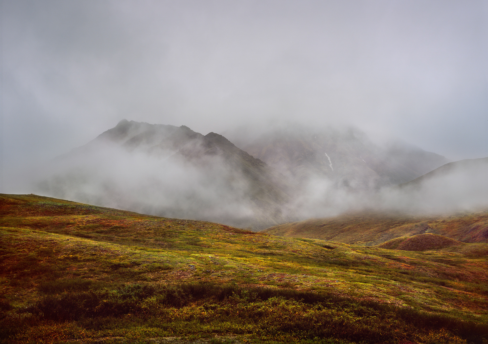
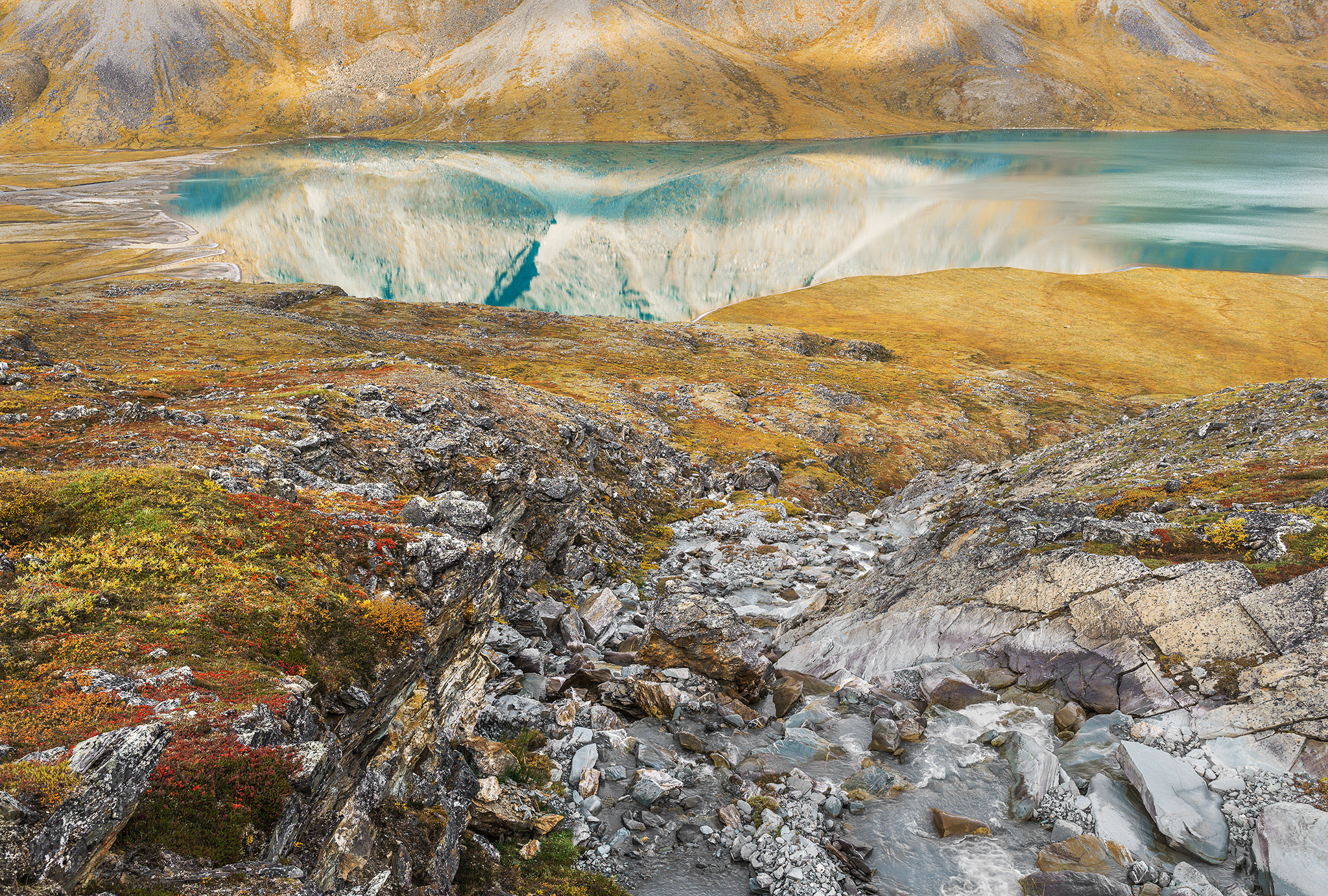
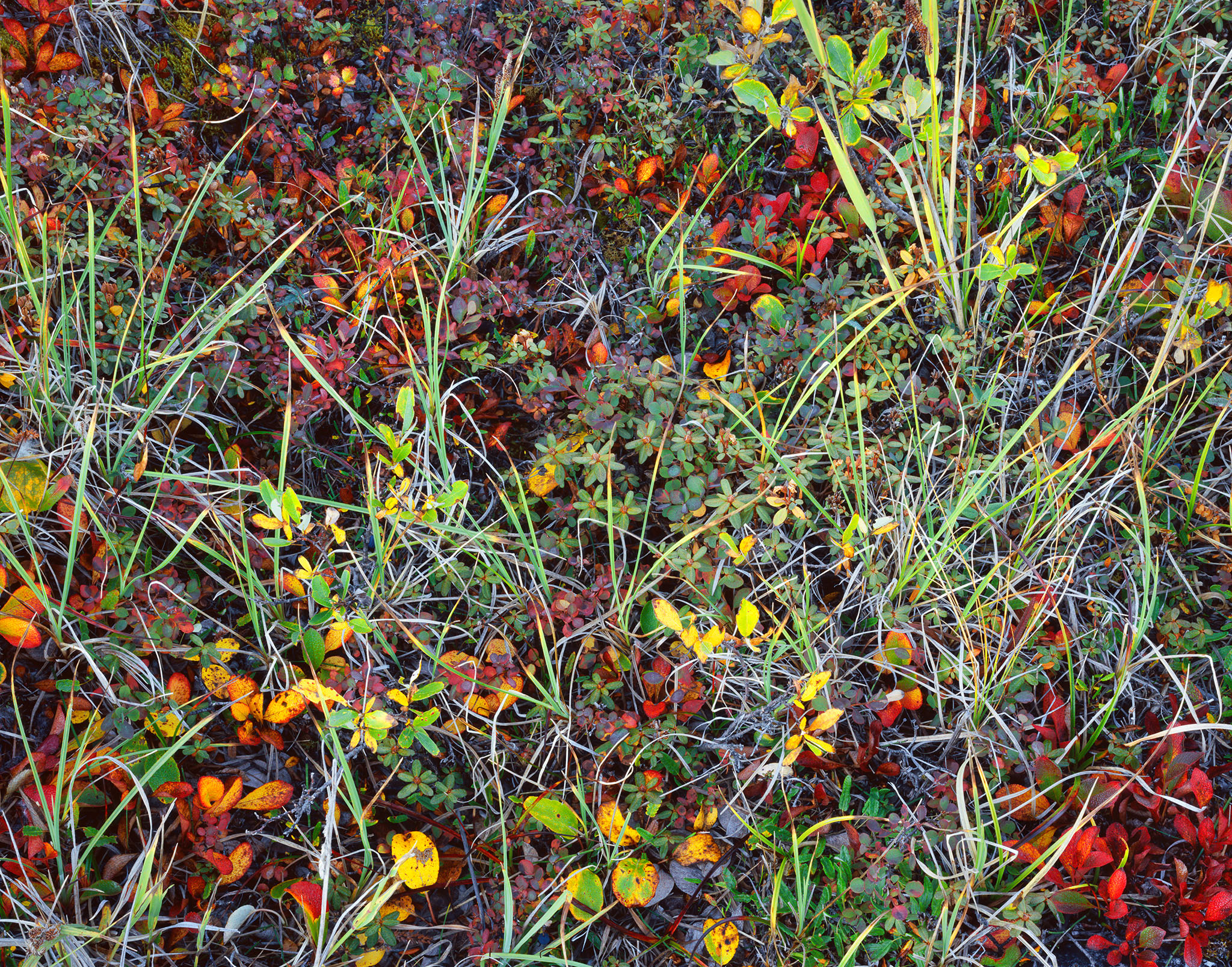
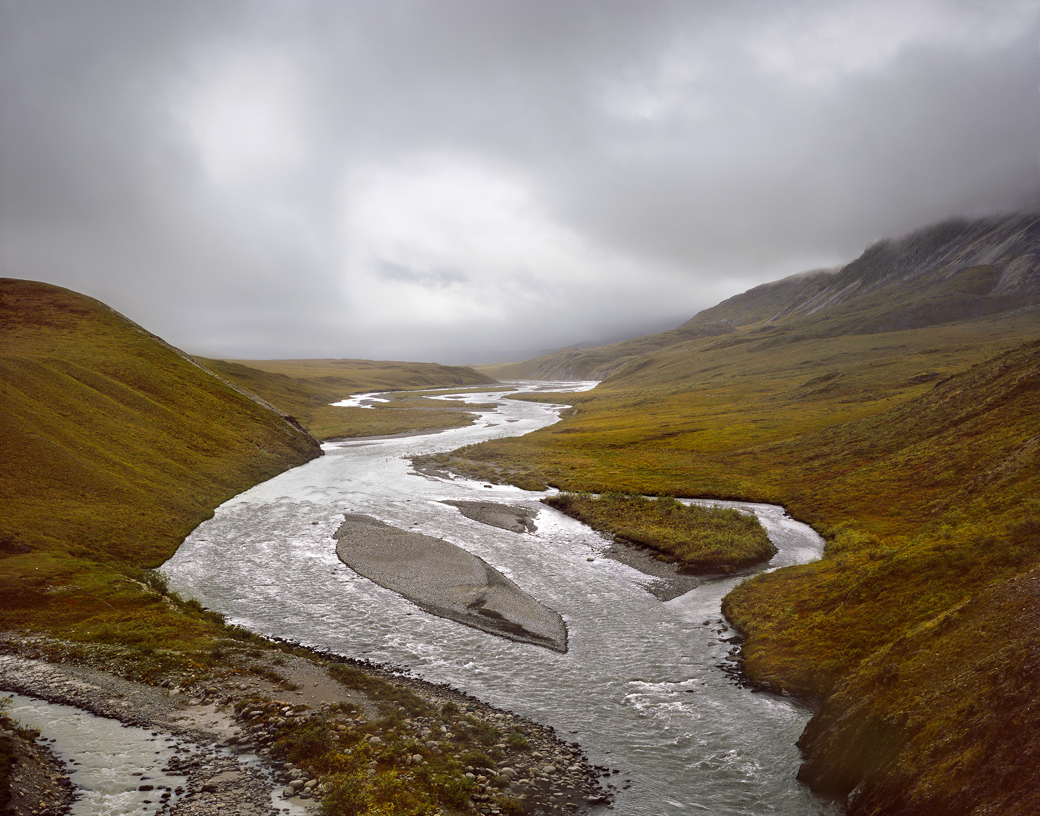
The next morning, we inflated the squishy raft and packed our gear. We shoved off into a swift current that was easy to manage. No gravel bars to avoid, certainly no steering through difficult rapids. We stopped early to camp. The stream alongside us was lively, tumbling down a steep grade into the main river channel. A gentle tundra slope, alive with color, fanned upward into the peaks. The light was soft and made gentle moves and shifts.
I became absorbed, mind and body, into the landscape. There had been other times—climbing an ascending ridge in a rhythm of movement and breath, walking a forest path through dappled light, sun warming a night-cooled meadow—that made me feel as fully aware as I was then.
I made my first two photographs of the trip using my mainstay equipment: Linhof 4x5 view camera, Gitzo Studex tripod, Arca Swiss ballhead, and Fuji Astia film. Making the photographs got me past the inner tension of wanting to see and create a composition. Like sitting at the bottom of a mountain is for the mountaineer: It’s a relief to start the process of climbing. Having mind, body, equipment, and situation come together and work together is as good as it gets.
Lost in thought, I wandered back to camp, where Danny raced into my serenity. Apparently, there were three sheep hunters stranded on the opposite shore. The river was up, and they couldn’t make it back to our side, the side they were camped on. Okay. Tom and I followed Danny down to the raft. I could see the hunters on the far shore, and Danny was preparing to launch the craft. Tom and I decided to get in as well. We grabbed paddles and pushed off from the shore. Danny shoved hard and then belly-flopped into the water. I couldn’t tell if he was going to try and haul himself into the raft or simply grab the bowline in his teeth and tow us across the current. He took the former option, grabbed a paddle, and pulled hard for the opposite shore.
Danny’s enthusiasm did not surprise me. I had known him for a long time, and he never did anything in a small way. A Force of Nature. I had watched him carry someone at a run with a sprained ankle, collect firewood by the cord, and duct-tape ill-fitting crampons onto tennis shoes. The young version of him cutting fire line as a U.S. Forest Service hotshot would have been fun to watch.
The hunters were grateful for the ferry across the Hula. Our trip continued to the confluence of the Hulahula and Koloktuk Creek.
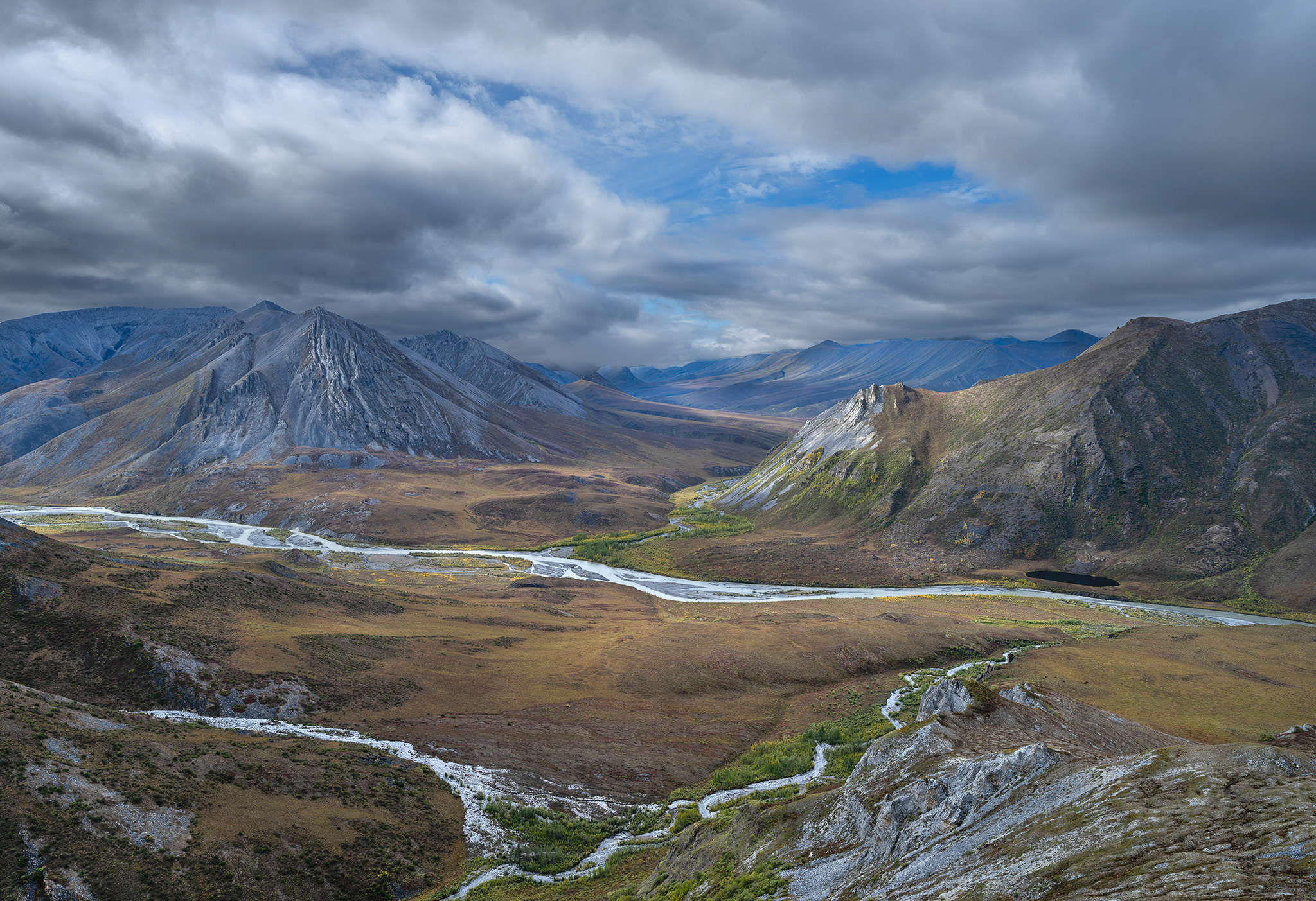
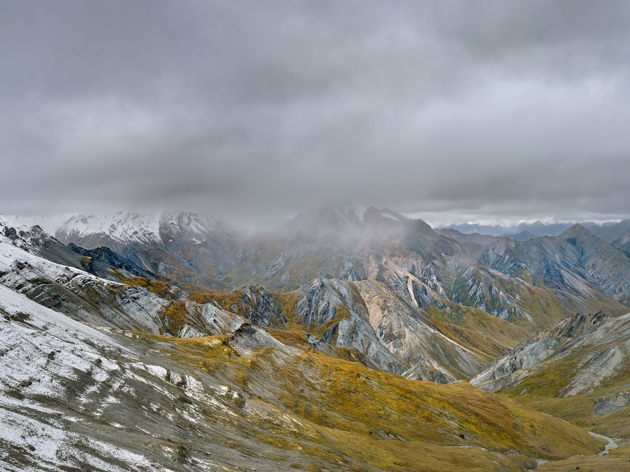
I walked along the creek for hours. The multi-colored carpet of the tundra worked on me like a kaleidoscope. Patterns and colors where a stop to consider a photo was inevitably abandoned, as the next step or a turn brought on new variations of crisscrossing lines, shapes, and textures. The day of our excursion to Mount Michelson, we crossed over a gentle ridge and got a view of the Esetuk Glacier below us. It made a broad, gradual, elegant sweep into the cirque below Michelson and Tugak peaks. Large crevasses cut across the ice-exposed expanse. We made our way onto the concrete-hard ice and walked toward the head of the valley. The 8,852-foot summit of Michelson sat on the north side of the glacier and was just out of view. It was easy to walk around the crevasse openings. The air was warm in the late afternoon. A loose scramble took us to an easy walk along the summit ridge.
At the summit, a 360-degree view extended to the Beaufort Sea and across waves of peaks. By the time we turned toward our return route, we realized that we wouldn’t make it back to camp before the Arctic twilight. Stopping along the way to wait for morning light wouldn’t be a problem. It did get dark enough to make walking a challenge, but a large flat rock tablet along the way made for a perfect nap spot.
Just as I was sinking into my first dream, Danny shook me awake. “Check out the strange clouds.” he said in a questioning tone. My first thought was, Oh shit, a storm is moving in.
Wispy, ephemeral clouds had appeared and seemed to be headed in our direction. As they twisted and turned, we realized they weren’t clouds at all but the northern lights! Their color shifted in intensity from dark to light green as if putting on a live performance. The lights passed overhead and finally lost their intensity. It’s here and then it’s gone. At around 3 a.m., it was light again, so we covered the last leg back to camp. I made a batch of pancakes and then read, listening to the rise and fall of the sound of the Hulahula. Water therapy.
Further down the river at the outlet of Esetuk Creek, a dismal fog-and-rain morning occasioned another stroll through the colorful tundra. The fog broke open, and diffuse light then played across the river and adjacent hills. The tundra color was deeper in the overcast. I made two photos over the course of the morning.
Back in camp, we brewed up coffee and wondered if the slow-leaking raft would survive to the end of the trip. A few shafts of sunlight materialized, so we decided to pack up and head downriver, where a couple of Class III rapids waited. After the short and exhilarating rapids, we headed into the exposure of the Arctic plain. The air off the Beaufort Sea bit harsh with cold. We pulled up onshore to camp on a gravel bar with sparse willow trees that did little to break the cold breeze. The fire we got going helped, but the warmth would be short-lived, and an early dive into the tent was called for.
As we headed further into the Arctic plain, even with the sun out we were chilled. Sitting in the boat at water level didn’t help, so it was best to keep moving. We passed what I assumed was a two-story hunting house. The plywood sides poked skyward and looked out of place with the landscape.
The outpost later became the landmark of a grizzly bear encounter: Sometime after our trip, a grizzly pulled a couple out of their tent, mauled them, and killed them—their rifle was no use. Soon after, the same bear chased a group in a raft down the river. The group escaped only when the current outran the bear.
We pulled off the river at a marked tundra airstrip. We were scheduled to be picked up the following day. I leaned against the cutbank of the river and planted my boots in the water to feel it rushing by. I had a bit of Arctic Dreams to read. Perfect timing. The end of a great book and trip.