
Adventures in the Faroes

Ars Silentium
Landscape photographer with a passion for the north. Nature has always played a significant part in my life. When I was young, I used to spend a lot of time in the woods marvelling at the beauty around me. I never lost the enthusiasm for nature when I grew up. The urge to capture nature's beauty was a logical next step for me. flickr/
The north! The north always fascinated me. I like the silence and the vastness of the Nordic countries that you won't find in Central Europe anymore. So, it's more than logical for me to travel to the north to flee from the noise and bustle of my overpopulated home country. I've been to Finnish, Norwegian and Swedish Lapland, exploring the breathtaking landscapes that lay before me.
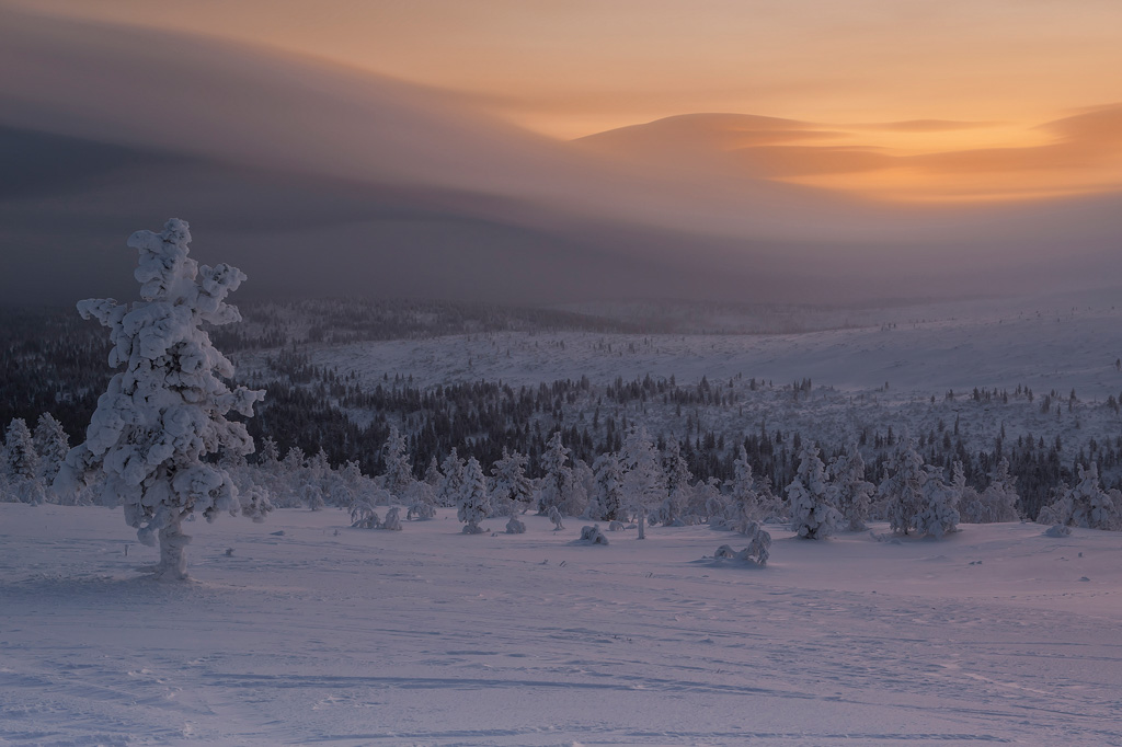
Deep Cold, Finnish Lapland, Inari County
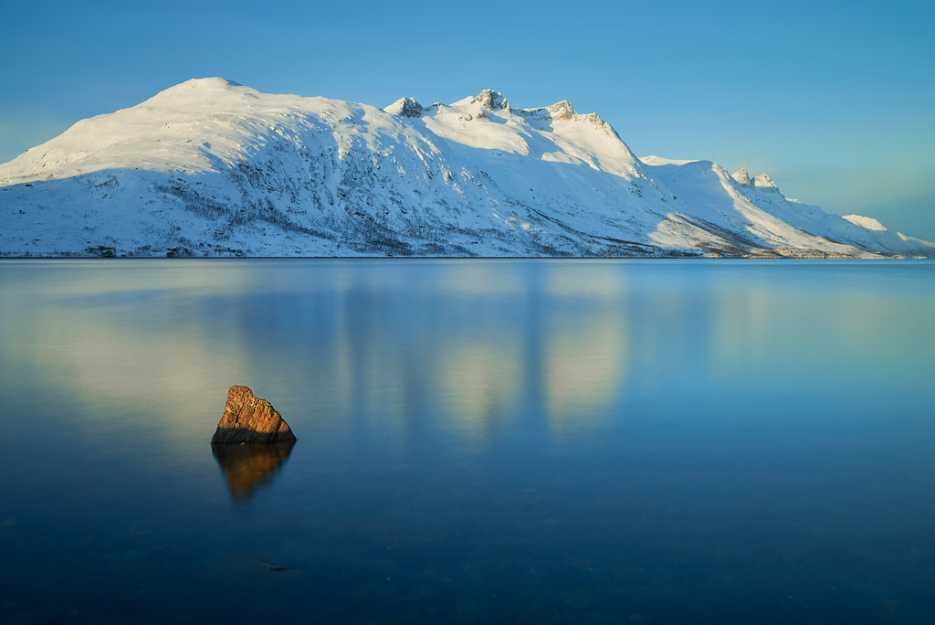
A Breath Of Warmth On A Cold Morning, Norwegian Lapland, Troms County.
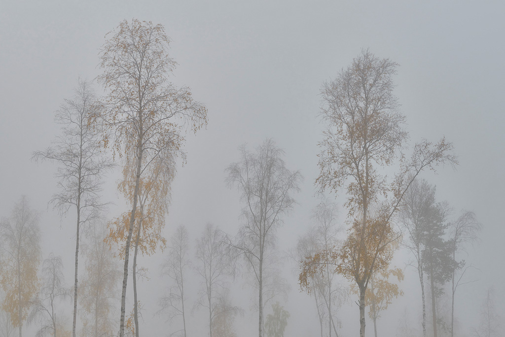
Gathering Of The Birches, Swedish Lapland, Norrbotten County
Enjoying the hikes, the cool fresh air and the loneliness. I feel uncomfortable among humans. The worst part is returning home after weeks of solitude. To distract myself, I'll look for future destinations that I might want to visit sometime.
The European Nordic area consists of five countries and three autonomous regions. Denmark, Finland, Norway, Sweden and Iceland plus the Faroe Islands, Greenland and the Åland Islands. Denmark might be a tad too populated for my liking. I'm sure there're some beautiful places to photograph, but so far I'm not very keen on visiting this country yet. The same goes for Iceland. Although Iceland's population is very small, one of the smallest in Europe, the country is overrun with photographers. The motto seems to be: "Go there before you die!“ Seriously?! If I see any more photographs of Jökulsárlón, I might lose my mind!
Kind of special are the Åland Islands. It's a Finnish region (however the people of Åland speak Swedish) that consists of an archipelago lying in the Baltic Sea with an area of barely 1,600 km². The archipelago consists of 6,757 islands, skerries and rocks, of which 60 are inhabited. I haven't had a critical look at the Åland Islands yet, but the autonomous region might be worth visiting in the future.
The other two autonomous regions, Greenland and the Faroe Islands are integrated parts of the Kingdom of Denmark. However, both are self-governing countries within the Danish Realm.
I'd love to visit Greenland one day, but unfortunately, it's pricey to travel there. Greenland has no roads, so getting around wouldn't be easy.
The Faroe Islands, also known as "the islands of sheep“, lie in the Atlantic Ocean, halfway between Iceland in the west and Norway in the east, and north of Scotland. The country is a bit smaller than the Åland Islands, around 1,400 km². It consists of 779 islands, islets and skerries, of which 18 are major islands. The capital and largest city are Tórshavn on the island of Streymoy.
Seeing pictures and reading about the history and background of the Faroe Islands sparked my interest. I had to visit these magical islands. Getting there is fairly easy. Just book a flight to Vága airport, rent a car and accommodation and you're good to go!
You have to keep in mind, though, that the Faroe Islands is a small country and finding a place to stay can take time. Booking a couple of months in advance is adequate. I avoided the high season, which starts in May and ends in September. Most tourists come to the Faroe Islands in July and August. I wouldn't recommend visiting the country then. http://www.airbnb.com is a good site to look for accommodations.
Furthermore, having the internet at my cottage was extremely helpful as the weather in the Faroe Islands is very fickle. It's possible to have rain in the west and sun in the east. You can even experience all four seasons in one day! To know where to go helped a lot! A reliable weather forecast site is http://www.yr.no/place/Faroe_Islands/. The forecast was mostly spot-on! I also used the internet to check for auroras or how Tim once put it: "green shit in the sky!“ A good site for Aurora checking is http://www.aurora-service.eu/aurora-forecast/.
Whenever I travel, I have my Nikon D800E with me, just one body, along with two zoom lenses, the AF-S Nikkor 24-70 mm f/2.8 G ED and the AF-S Nikkor 70-200 mm f/2.8 G ED VR II plus the AF-S Nikon Teleconverter TC-20E III 2.0x. Filter wise I use B+W, Hoya and Lee. The tripod is a Manfrotto 055CXPRO4 with the Acratech GV2 Ballhead.
I knew from the beginning that the Faroe Islands has no trees. If I wanted to take pictures of arboreal stuff, then I would have gone to Finland or Sweden. Artistically, you are somewhat limited to photographing coastal and mountain sceneries. I wouldn't be able to include a lone tree or a rotten branch lying on the ground in one of my images. Instead, it would be stones, rocks and the like. Another possibility would have been to take pictures with the tele-lens. Close-ups of cliffs, mountains, waterfalls. Unfortunately, I mostly used my wider lens. In hindsight, I regret not getting the tele out of my rucksack more often. I guess I was too overwhelmed by the stunning scenery which I wanted to capture with a wide-angle lens.
The most challenging aspect in the Faroe Islands is by far the weather. You always have to be prepared to get soaked even if the forecast says otherwise. More problematic, though, can be the wind. Strong winds don't work well with long exposures. A camera on a tripod is prone to shakes and vibrations when the wind whistles around your ears. You somehow have to prevent that. What I like to do, is to set up the tripod low and sit or stand close to the mounted camera. It mostly works. If the wind comes from the front, then it obviously doesn't.
Getting to locations on the islands is easy as the roads are in mint condition. You don't need a 4x4 wheel drive. It's forbidden to go off-road! Bridges and undersea tunnels connect most of the islands. You have to watch out for sheep on the road, though! They are everywhere! On the road, on the beach, on the hills, in the mountains, in the villages. Everywhere! They rule the Faroe Islands! Hence, there's a lot of sheep droppings. You have to take that into consideration when shooting wide and to choose a "foreground in-your-face“ composition. You definitely don't want droppings in your frame. I had no intention to spend hours in post cloning them out. So I always kept an eye out for any dung before shooting. I'm serious!
On my first day, I wanted to hike up to the Tjørnuvíksskarð north of Saksun even though the weather didn't seem too promising. Saksun is a beautiful small village on the island of Streymoy and is surrounded by high mountains. Unfortunately, the weather didn't play ball. Horizontal rain and gale-force winds made hiking unpleasant. I had to abort my mission. Despite the weather, I set up my tripod and tried to take pictures. Of course, it was a fruitless effort. The rain was too unforgiving.
The storm did not abate much on the next day, and it still rained. My intention was to explore Tjørnuvík and try to shoot something from above the picturesque village. Tjørnuvík is situated in the north of Streymoy and has a charming sand beach, which is quite rare in the Faroe Islands. It's most famous for its view of the sea stacks of Risin og Kellingin (The Giant and the Witch). The legend goes that the pair were sent to the Faroe Islands to pull the Islands to Iceland. The giant's wife, the witch, climbed the mountain of Eiðiskollur (352 m) to tie the Faroe Islands together, so that her partner, the giant, who was standing in the sea, could drag them to Iceland. But she wasn't careful enough, and the north of Eiðiskollur cracked. It took them far too long, and as they were about to head back home to Iceland, the sun rose and turned them to stone.
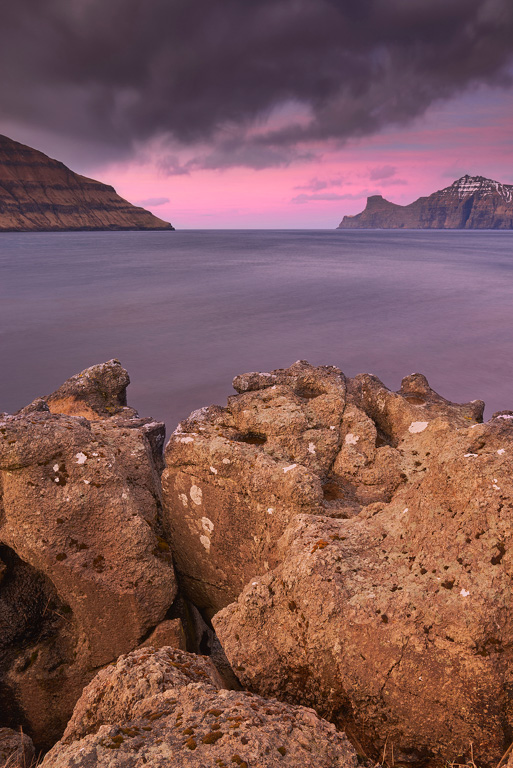
Once the rain ceased, I headed up the steep hills south-west of Tjørnuvík. I got lucky this time and was able to shoot my first picture of the Faroe Islands.
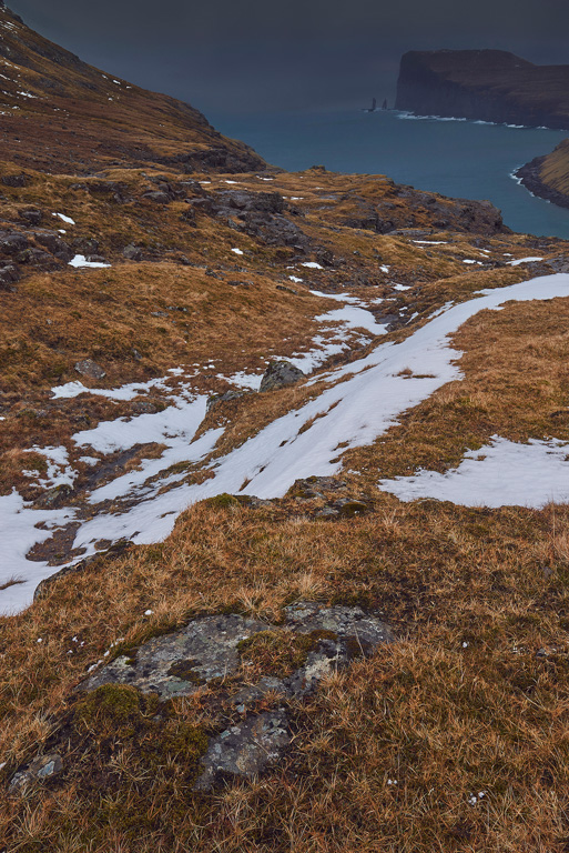
The sea stacks of Risin and Kellingin seen from high above Tjørnuvík. The flat mountain in the background on the right is Eiðiskollur (352 m).
I chose a classic composition for this image. A flat stone in the foreground and the snow leading the eye to the base of the mountain on the right. From there further on to Eiðiskollur and the sea stacks. The steep slope on the left balances the stuff on the right. I try to keep it simple. No mumbo jumbo compositions.
My mood heightened after taking the photo despite the challenging weather and I was looking forward to the next day. If I knew what awaited me the following day, my mood might have been less optimistic.
Fuglafjørður, which means "fjord of birds“, is a bigger village on Eysturoy's east coast. It has a lovely hiking route up to Fluglafjarðarskarð and down to Hellur in the north. I almost made it to the top but had to abort mission once again as the wind picked up speed. To cap it all, it started to rain cats and dogs. Back in Fuglafjørður, I was soaked to the skin! No more hiking for today!
At least I could shoot one picture from the back seat of the car. I somehow managed to set up my tripod on the back seat and shoot across the street through a half-opened window. I took a picture of a waterfall just outside the village of Fuglafjørður.
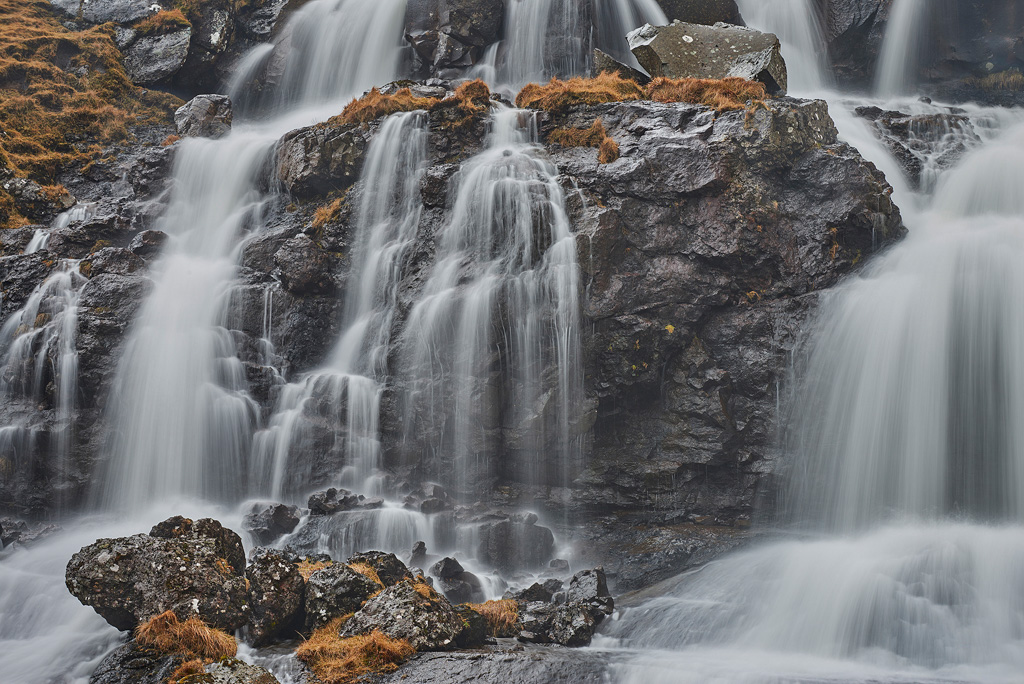
Close-up of one of many waterfalls around Fuglafjørður shot from the back seat of the car.
The two stones, the one in the bottom left and the other in the top right are a major part of the composition. I tried to place them adequately into the frame.
It can be helpful to come up with ideas when it's raining buckets. Drivers in passing cars might have thought I'm doing a speed monitoring operation.
The next day my throat was sore thanks to the wind and rain, and I coughed a lot. No time to rest. Cough pills will do. Thankfully, the weather showed its happy face now, and I could take some shots without shelter over my head. I made a trip up a narrow mountain road that leads to Sornfelli, a 749 m high mountain on the island of Streymoy. On Sornfelli once was a NATO base, where air and sea traffic was monitored. Due to protests in the 1980's, the base was closed. Driving up was quite scary because of ice and snow. The spectacular views, though, made it more than worth. Even better, there was hardly any wind.
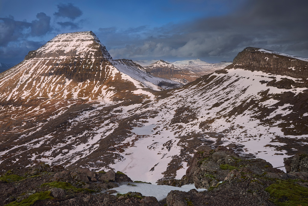
Mount Skælingsfjall (767 m) on the left bathed in the afternoon light and mount Stallur (614 m) on the right in the shadows.
As I waited for sunset, I tried a composition I wasn't sure if it would work. I put a crack in the ground in the centre of the frame. I wanted to use the crack as a line pointing to the setting sun. Kind of. At first, I thought the picture looked okay, but when I processed it, it looked weird. So I cropped it quite a bit, to get the crack more to the left.
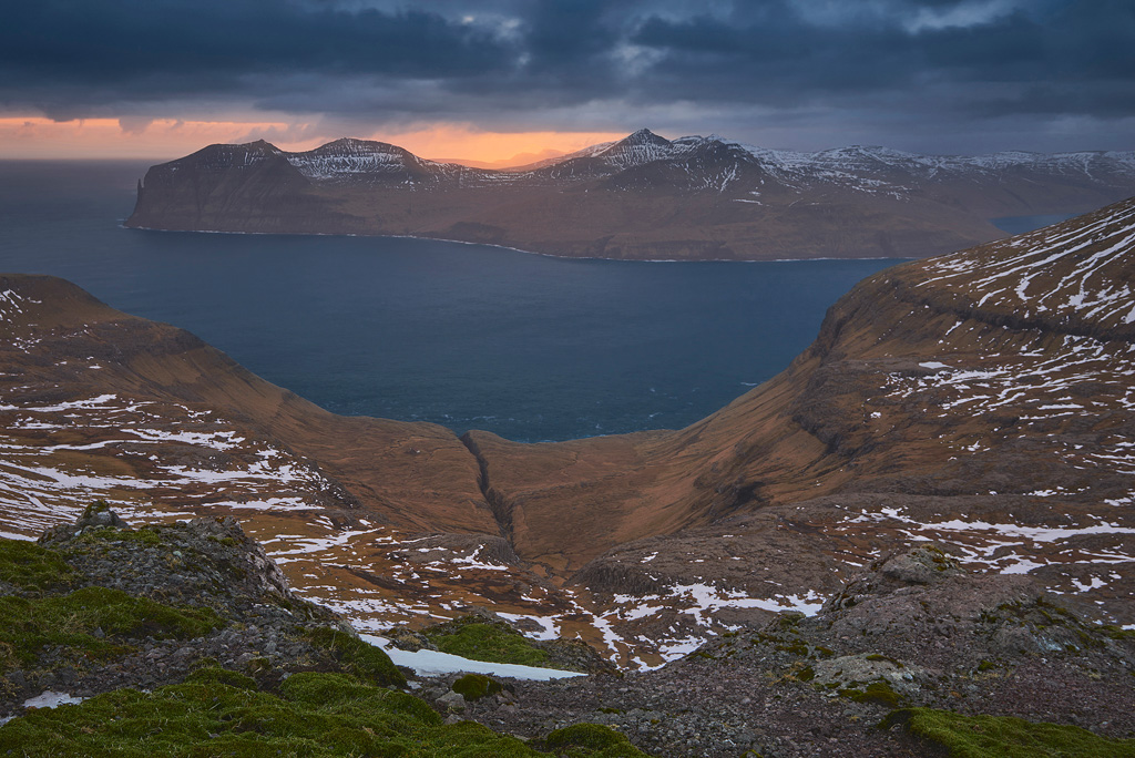
View of the mountains of the island of Vágar at sunset.
So far, I explored the islands of Streymoy and Eysturoy and wanted to delve into the other islands now. I decided to head to Borðoy the following day, which is one of the Northern Islands. The Northern Islands are situated in the northeast of the Faroe Islands and are referred to as Norðoyar. There are six of them, from east to west, Kalsoy, Kunoy, Borðoy, Viðoy, Svínoy and Fugloy. The second largest city of the Faroe Islands, Klaksvík, is situated on Borðoy.
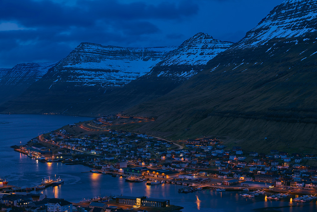
Klaksvík, the city of the Northern Islands. It's the second largest town in the Faroe Islands.
To the north-west of the town lies Klakkur, a 413 m high hill with fantastic views to the islands of Kalsoy in the west and Kunoy in the north.
Early evening light and the island of Kalsoy, stretching to the north. A bit more to the left and the sun would have blown out the picture. Balancing the composition was crucial.
I didn't ascend Klakkur due to strong winds. Instead, I found a spot below the peak where I could shoot pictures.
A dark sunset photographed below Klakkur (413 m). Below the sun the village of Leirvík, barely visible.
Up until now, I haven't taken any images from sea level. To change that, I drove to Elduvík the next afternoon, a quaint village in the north of Eysturoy. Elduvík is split into two parts by the brook Stórá, and a lot of sheep roam the few narrow streets. Unfortunately, the wind was back in full force again which made photography a challenge.
I found a scene that I wanted to capture and decided to shoot a long exposure. So I set up the tripod very low and mounted the camera on it. I sat down as close as possible to the camera, composed a picture and shot. The Little Stopper helped to lengthen the exposure to ten seconds.
The brook Stórá splits the village of Elduvík into two parts. On the left mount Tyril (535 m). On the right the island of Kalsoy, illuminated by the sun.
The big stone in the brook balances the sunlit chain of mountains. There is a little “extra” in the frame. It's the little red stone in the bottom left corner. It should tease the eyes a bit. Despite the strong winds, I got away with some decent images.
A pinkish dusk at Elduvík. The bright stripe below the cloud on the left is not where the filter ended. The cloud looked like that.
For the next day, I planned a trip to Suðuroy. Suðuroy is the southernmost island of the Faroe Islands. To get there, you have to take the ferry from Tórshavn to Tvøroyri. It's a two-hour trip. It's possible to travel to Suðuroy in the morning and be back in Tórshavn in the evening.
Photography wise it wasn't the best weather. The sky was mostly a milky, flat grey.
I first drove to Sandvík, the northernmost village on the island. Sandvík's beach is a large stretch of sand where you can sometimes observe seals.
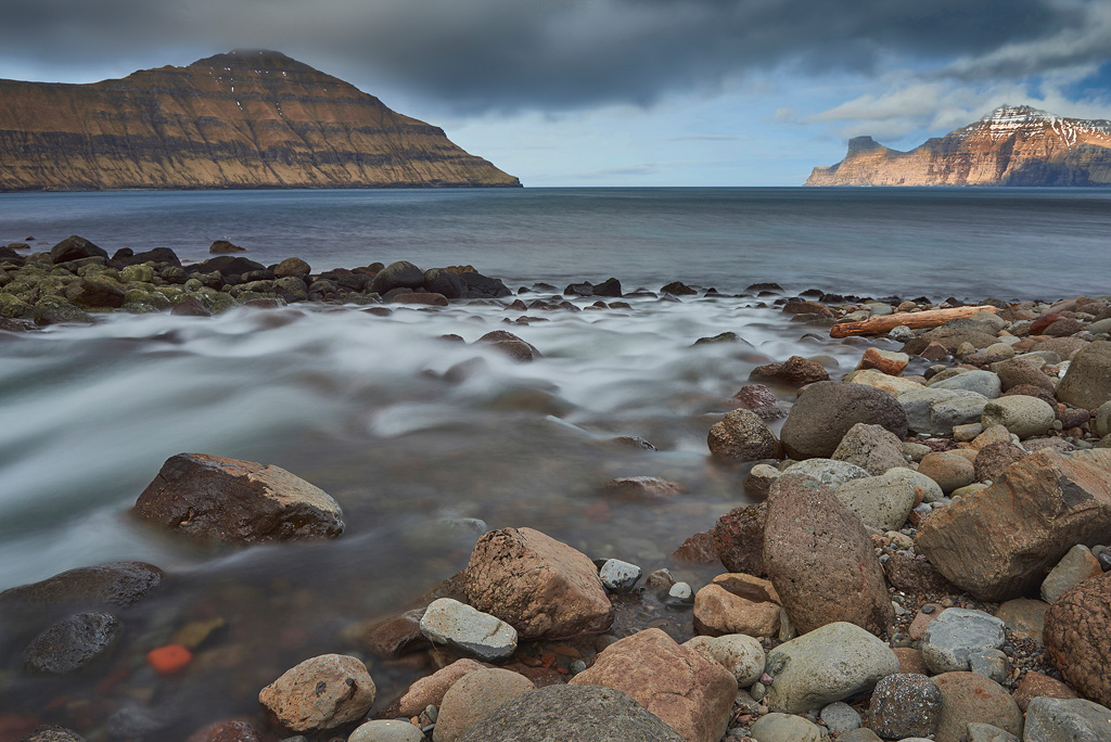
The beach of Sandvík with views of the islands of Stóra Dímun on the left and Lítla Dímun on the right in the far background.
I then made a trip to the south of Suðuroy to Beinisvørð. Beinisvørð is a vantage point from where spectacular views of the west cliffs can be enjoyed.

The huge west cliffs of the island of Suðuroy seen from Beinisvørð.
The drive up was one of the scariest things I've experienced so far. The road is steep and barely two metres wide with no guardrail. One false steer and the car would have been tumbling down the steep mountainside. Scary!
Thankfully, the other way down was less frightening. I ended up in Sumba, the southernmost town of Suðuroy. Driving from one end of the island to other takes less than an hour.
The weather didn't get any better, so I called it a day and drove back to the port.
After a pleasant night's sleep, I checked the weather and aurora forecast. Clear skies and a geomagnetic storm of G1. Could it get any better? Maybe I get lucky tonight? I poured over the map, trying to find places that have a good view to the north. A view of the sea would be nice with maybe some mountains as the back drop. Tjørnuvík and Elduvík were possible. But I've already been there. I didn't want to revisit places I've already photographed. I wanted something fresh. Maybe Gjógv on the island of Eysturoy? Gjógv has views to the east and north. That could work. The village's name is Faroese and means “gorge”. The sea-filled gorge runs north to the sea from Gjógv. There is also a large stretch of rocky beach with pools filled with sea water. I could use them as foreground interest. There was plenty of time to kill. Instead of hanging around till sunset, I decided to try to ascend the highest mountain of the Faroe Islands. Slættaratindur (882 m) is just around the corner.
I almost made it to the top, but large snow fields prevented any further progress. To get to the peak, I would have needed crampons which I didn't have. On a clear, sunny day you can oversee the whole of the Faroe Islands on top of Slættaratindur.
Looking back down the steep slope of the mountain of Slættaratindur (882 m). Ice and snow prevented any further progress. Not seen in the picture.
Back in Gjógv, I photographed the last light of the day. The setting sun lit up the mountains of Kalsoy nicely.
![The setting sun illuminates the chain of mountains of the island of Kalsoy. [14 Gjógv Minimalism] Pastel colours at dusk.](https://www.onlandscape.co.uk/wp-content/uploads/2016/08/13-Mountains-Of-Might.jpg)
The setting sun illuminates the chain of mountains of the island of Kalsoy.
Gjógv Minimalism, Pastel colours at dusk.
To be honest, I don't like taking pictures in the near dark. Composing an image at night is extremely difficult. At least for me. You can't see the horizon through the viewfinder. You can't see crap. When shooting at night, the horizon on most of my pictures is not straight. I have to fix that in the post. It's annoying!
I fiddled with my headlamp, turned it on and off and tried to compose pictures. The sky put on quite a show.
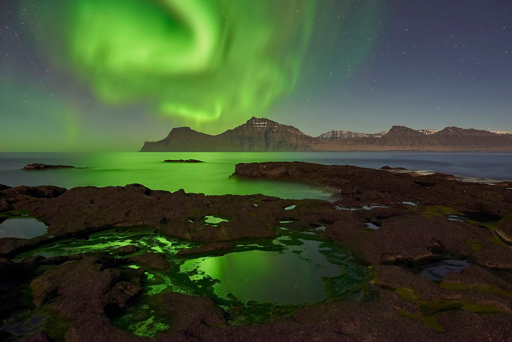
Amazing display of auroras dancing in the night sky of Gjógv.
"Green shit“ galore! Tim would've been a happy chap! As the moon shone brightly, I had to be careful not to have any shadows of my tripod or myself in the images. Furthermore, I had to watch out not to break my neck on the slippery, algae-covered rocks. At least I came away with some pictures that I felt pleased with.
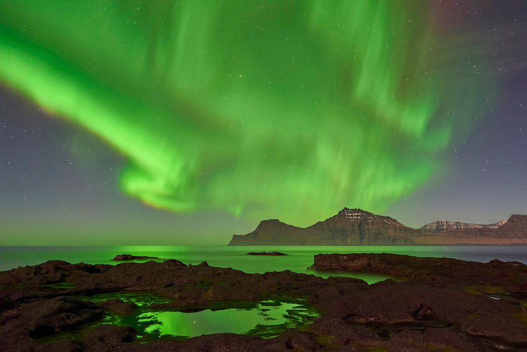
A huge aurora over the mountains of Kalsoy
It got quite late, so I wanted to take it easy the next day.
I drove to the Northern Islands once again. This time further up north through the island of Borðoy to the island of Viðoy. Viðoy is the northernmost island of the Faroe Islands. The road ends in Viðareiði. Mount Villingadalsfjall (841 m) towers over the village in the north. I was more interested in the rocky beach, though, where you get some nice views of the island of Kunoy.
As there was plenty of time till sunset, I lay down on the rocks and took a nap. There was no need to rush around looking for compositions.
A couple of hours later I set up my tripod and put my camera to use, capturing the last light of the day. That was pretty much it. I drove back to the cottage.
The island of Kunoy seen from the rocky shore of Viðareiði at the last light of the day.
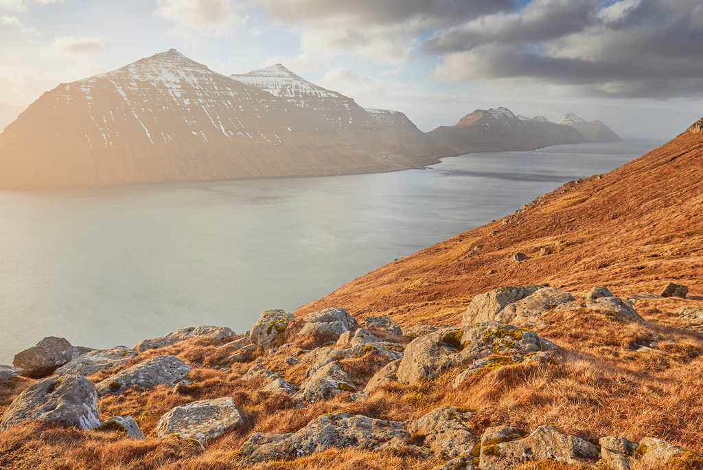
Vágar is the most westerly of the large islands of the Faroe Islands. The airport is located there. I was interested in the sea stacks that can be seen from the picturesque village of Bøur. Drangarnir and Tindhólmur have been depicted on many paintings. It's a well-visited location and maybe a bit iconic. At least it hasn't gotten a hotspot for landscapers yet. I hope it stays that way. I wandered around the small stretch of sand beach looking for compositions. It was the only afternoon; the sun would set in about four hours.
Instead of lounging about, I decided to head to Gásadalur, only a ten minutes drive from Bøur. Gásadalur is most famous for its waterfall; it's probably the most photographed location in the Faroe Islands. A true hotspot for landscapers. I was not surprised to see a landscaper hanging about with his group waiting for sunset. They were going to photograph more of the same. If you type in “Gásadalur waterfall” in any search engine, you get hundreds of images with the same composition. There's not even variety in the shots. What drives photographers to take pictures of the same over and over again? Maybe it's an ego thing? Look! I've been there too! The Faroe Islands has much more to offer than just this waterfall.
I headed back to Bøur for sunset. As the end of the day approached, I set up my gear. Sunset wasn't all that great, so I turned to the Little Stopper for some help. The three stones in the bottom should “depict” the three sea stacks on the horizon. It's a bit far-fetched, I know, but I liked the idea.
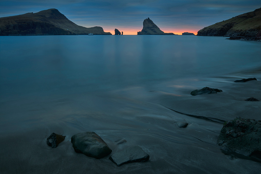
The sea stacks of Drangarnir, Tindhólmur and Skerhólmur, from left to right.
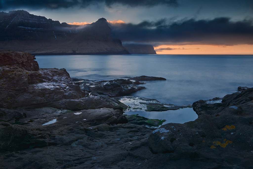
Everything comes to an end. Tomorrow would be my last day in the Faroe Islands, which I spent in Funningur. Funningur is situated on the island of Eysturoy and is surrounded by the two highest mountains in the Faroe Islands, Slættaratindur (882 m) in the west and Gráfelli (856 m) in the north-west. The village has a small harbour. However, there are no boats. I went down to the shore. To the northeast, you have a nice view of the island of Kalsoy. I spent some hours there and fell into musings. [Photo 19] It's been a lovely two weeks in the Faroe Islands. The country has so much potential photography wise. Mountains that rise high directly from the sea. Huge cliffs, a stunning coastline, impressive sea stacks, rocky and sandy beaches, however, the latter is rather rare, thundering waterfalls, picturesque villages. You could spend weeks photographing the Faroe Islands, and you would have still only scratched the surface. Fortunately, the country has not been overrun by photographers like Iceland yet. It's still relatively untouched by landscapers. I just hope that the Faroe Islands won't suffer the same fate like Iceland. That would be a real shame!
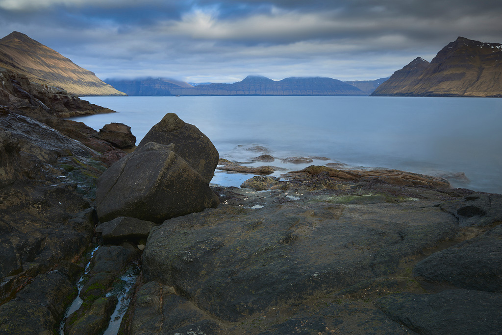
A dull and grey day in Funningur. I've waited hours for this shot and got rewarded for my perseverance.
It's been a lovely two weeks in the Faroe Islands. The country has so much potential photography wise. Mountains that rise high directly from the sea. Huge cliffs, a stunning coastline, impressive sea stacks, rocky and sandy beaches, however, the latter is rather rare, thundering waterfalls, picturesque villages. You could spend weeks photographing the Faroe Islands, and you would have still only scratched the surface. Fortunately, the country has not been overrun by photographers like Iceland yet. It's still relatively untouched by landscapers. I just hope that the Faroe Islands won't suffer the same fate like Iceland. That would be a real shame!