
A photographic exploration of the Wiltshire Watershed

Richard Draper
Richard Draper is an artist whose work brings together landscape, abstract and conceptual photography. His recent projects have explored visible and invisible paths in the landscape, and human interaction with them. His most recent solo show was at the White Horse Gallery in Marlborough and he exhibits regularly as part of Marlborough Open Studios. His work has also been shown in group exhibitions at the RWA in Bristol, the Martin Parr Foundation, the Swindon Museum and Art Gallery, the Richard Jefferies Museum and the Royal Photographic Society. In 2019 he completed an MA in Photography at UWE, Bristol.
It was Garry Winogrand who said that he took photographs to find out what something looked like photographed. By selecting a slice of space and time and freezing the moment we can later examine it at leisure. Understand it, give it meaning, enjoy it – for it cannot be repeated. I think I was unconsciously doing that here in this project. I had the idea but did not know where it would take me and only by taking the photographs has it become clearer.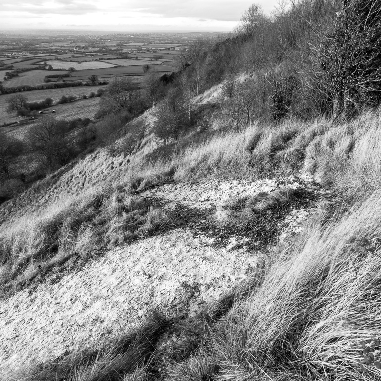
I can't quite remember why and when I decided to explore the watershed. Perhaps I was thinking, when walking nearby, about Mount Tronador along the great divide between Chile and Argentina, the border between nations that is also the watershed along the Andes.
There are in fact lots of watersheds everywhere as every stream has a boundary between the next one. What I was interested in though was the main watershed, the one which defines where waters flow in different directions. I found that Wiltshire is unique in England and Wales in having one point where the rains divide into river catchments that flow in three different cardinal directions. That point is just north of Devizes and those rivers are the Kennet/Thames (east to the North Sea), the Bristol Avon (west to the Severn) and the Hampshire Avon and River Test (south to the English Channel via Christchurch and Southampton respectively). Avon is the Celtic word for river. The watershed cuts across the county from the Gloucestershire border near Malmesbury, around Royal Wootton Bassett, south near Calne and almost to Devizes, then along the north of the Pewsey Vale, through Burbage and then out into Hampshire near Ham.
About a year ago I started exploring this invisible line. I didn't know what I was going to find or what I would find of interest to photograph. Or why I was photographing it, except that I thought this natural feature would be a useful thematic device. By definition the watershed is along the highest spots in the landscape, which although not very high compared to elsewhere (just 295m at the highest spot), would at least give good views and a perspective on the landscape. I quickly decided that I would produce work in black and white and, using the 2¼ inch square format of my old Bronica, would make the images square. And so, inspired by Fay Godwin among others, I started work. My digital SLR camera allows the live view mode to be set to square so it was easy to frame the images as square at the time of shooting, even though the raw files are recorded as full frame.
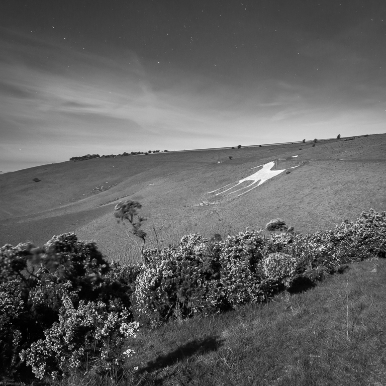
Some research with the OS maps showed that there was a number of man made features along this watershed. In fact, the whole watershed has been touched by humankind in one way or another. This has become the underlying theme to the work. Many of these man made features are linked to the fact that these are the high spots in the landscape. From Iron Age days there are several hill forts still carved into the land from 2000-3000 years ago – Oldbury, Martinsell, Knap Hill, Oliver’s Castle and Bincknoll. There is the Wansdyke, the pre-Anglo Saxon ditch which marks an unknown border. There was the 1643 civil war battle of Roundway Down in which the Royalists defeated the Parliamentarians. There are 4 white horses carved into the chalk hills, the latest at Devizes carved for the recent Millennium – the only one in Wiltshire to face right. We have 9 trig points (out of 250 in Wiltshire) along the way – those now redundant OS mapping points. One of them had been moved by a farmer to the corner of his field and another was completely smothered with undergrowth, and a challenge to find. The Kennet and Avon canal has its high stretch through the 450 yard Bruce tunnel, constructed in 1809. There's the derelict Wilts and Berks canal near Swindon, and other Victorian infrastructure which has been ripped up, like the two Savernake railway stations and the Midland and South Western Junction railway line. There are a couple of monuments (Cherhill and Ailesbury) erected by landowners in honour of their forbears.
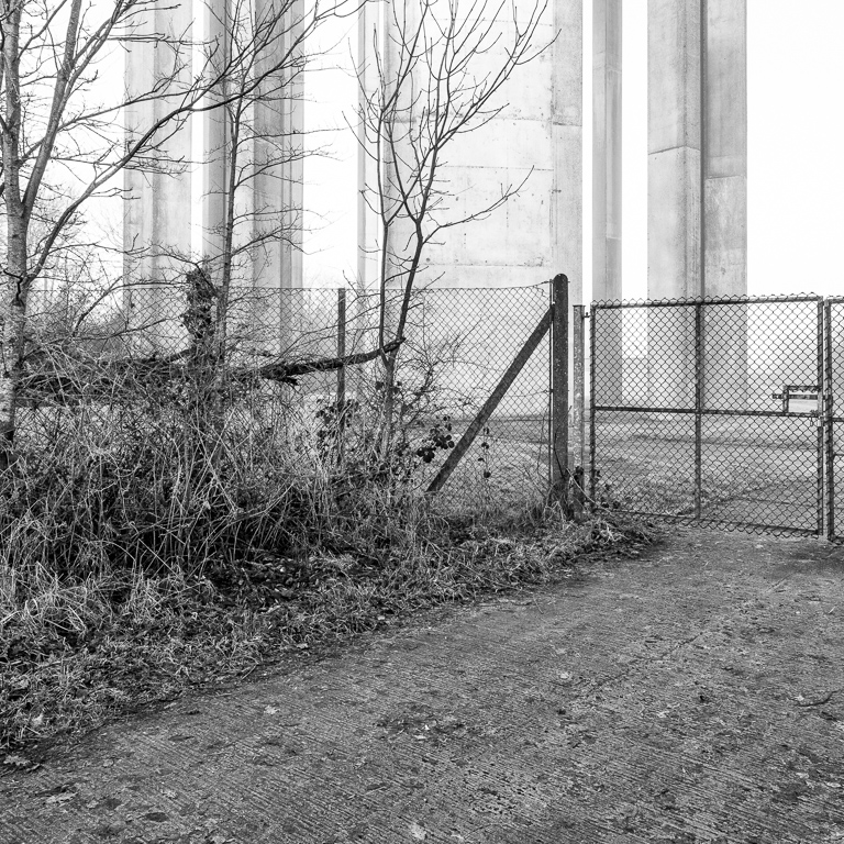
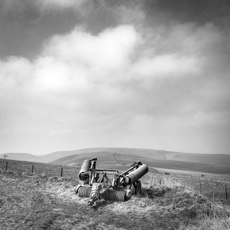
Modern transport bisects the watershed In a few places – the Great Western railway near Swindon, the Taunton line at Burbage and various main roads such as the M4 near Swindon and the A346 in the Savernake Forest. Farming is ubiquitous and has probably had most impact on the landscape, both arable and livestock. Numerous water reservoirs dot the watershed, including those maintained by the water utility companies. There are many long distance footpaths such as the White Horse Trail and the Mid Wilts Way.
By exploring this line I have been aware of connections with hundreds of previous generations who have lived on this land, fought for it, defended it, decorated it, developed it and passed through it. Standing upon the high spot in the landscape has practical reasons for surveying incoming armies and literally surveying the land (those trig points), but a good view is also good for the soul. I think of much of this landscape as classic Wiltshire in the way that we know it now – rolling hills of chalk downland with clumps of beech trees along the ridges. It may not have the grandeur of other parts of the country but it has its own particular beauty.
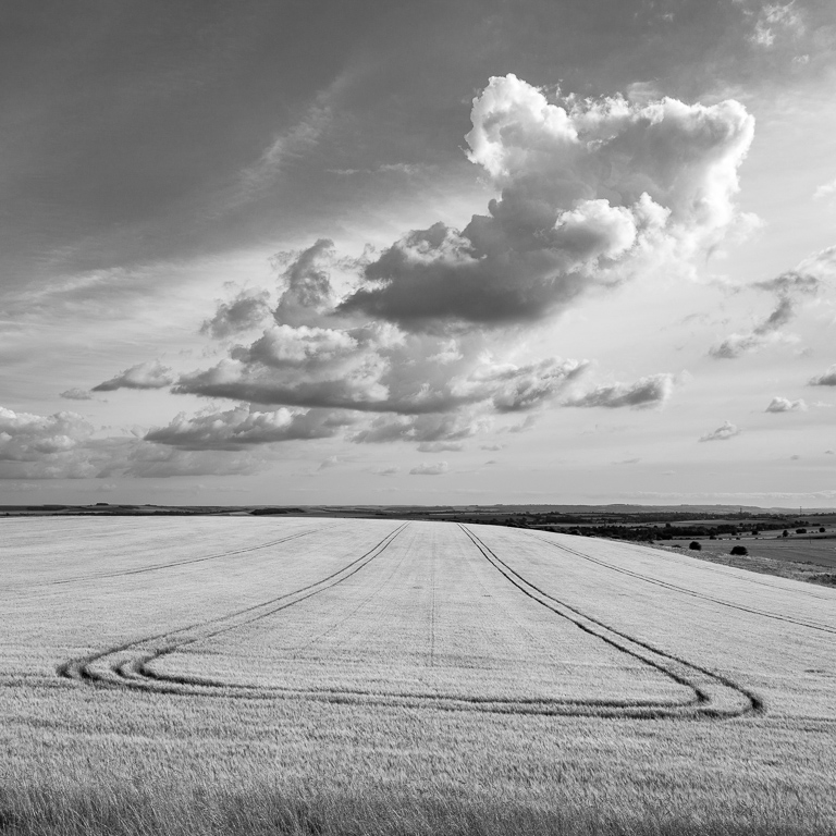
The underlying tension in these photographs is between beauty and utility. In nearly all the images, the hand of Man is visible, even if people rarely appear themselves. There really is no part of this landscape untouched. Our mark is seen in domesticated animals grazing in their fields, tractor lines in crops, Industrial Revolution architecture for canals and railways, benches to take in the view, footpaths across the land, relics from war, farm buildings and litter carelessly discarded. Modern society uses land for its roads, railways, electricity pylons, water towers and so on, as well as using land to produce food. Farming and leisure are the main activities today. Not all of this activity creates or even sustains beauty – but this is the challenge: to preserve beauty while providing utility. I hope that these images reflect that dichotomy.
What next? I have been exploring this part of the landscape for over a year now, having made many trips to all parts of the watershed in different seasons and exposed many photographs. With a project like this there is no obvious stopping point as the landscape is in continual change. However, the work is being exhibited in July and August and this has provided a clear deadline and moved the focus from producing work to editing, developing and presenting. It’s been a tremendous challenge to select images that stand up on their own in exhibition format but also fit into the narrative theme of the whole show. It’s in a book that the narrative can be developed further and I am currently working on a prototype using Blurb.
Humankind has shaped this landscape in all sorts of ways and in so doing has left marks from ancient history to the present day. Although this part of Wiltshire is a very worn landscape it retains its natural beauty, a testament to the fact that in spite of shaping the land for our use and survival, it has a permanence beyond the span of human lives. We can ponder the track that a raindrop takes if it (hypothetically) falls an inch this way or that and works its way down to a different sea. That has not changed and is as old as the hills themselves.
The work is showing in August as follows
White Horse Bookshop Gallery, Marlborough, Wiltshire SN8 1HW
August 4th to September 1st
Open 9 to 5.30 Mondays to Saturdays, 11 to 4 Sundays